
所在位置:首页 > 贸促动态 > 市长国际企业家顾问会议 > 顾问报告 > 正文
区域合作与环首都经济圈的发展——德意志银行集团董事长兼全球执行委员会主席约瑟夫•阿克曼
2012年05月29日 来源:中国国际贸易促进委员会北京市分会
德意志银行集团董事长兼全球执行委员会主席 约瑟夫•阿克曼
前言
本报告的重点是研究北京与周边河北省的县市城镇以及毗邻的天津市的经济融合现状。该区域有不同的名称,例如京津冀都市圈、环首都经济圈或京津走廊。无论用何称谓,这都是个多中心的地区,具有多元构架:一方面,有北京这样的大都市以及天津(与北京一样是直辖市)和石家庄(河北省省会)这样的大城市,人口均超过1000万;另一方面,河北省有多个人口超过200万的中等城市以及乡镇和农村地区。该都市区无疑是以北京(中国的政治文化之都)和天津(中国最重要港口之一)为主导的。
本报告由以下部分组成:
第一部分:概述有关经济地理学的学术理论以及其为何对社会经济发展至关重要。
第二部分:大都市发展的国际案例研究,涵盖发达经济体的转变历程和新兴国家大都市区的发展。
第三部分:从大都市发展的角度描述北京以及周边河北省和天津市的历史沿革,聚焦经济融合,评估政策措施和可能具有争议的议题。
第四部分:基于前述理论框架,并考虑到该都市区的历史沿革和现状,报告最后提出实现环首都经济圈综合发展的相关建议。
第一部分:经济地理概述
尽管亚洲有很多大型的连绵不绝的城市或都市区,但多数城市或都市区的开发都很少规划或者没有规划。结果导致这些城市中很多都面临诸如污染、交通堵塞、生活质量低、健康隐患多等问题。如果在制定发展规划中考虑到经济地理因素,那么除了可以避免因规划不善带来的问题,而且不同地区和城市也会从中受益,从而推动区域未来的发展前景和可持续性。经济地理是介于经济学和地理学之间的跨学科研究,关注地理如何影响经济活动的地点、分布和组织,以及经济活动对地理的影响。经济地理学者通过研究影响经济过程的地理因素,来解释例如工业或服务业聚集的地点,也研究诸如外部因素、累积优势和规模经济等经济力量如何影响经济活动分布地点,研究也进一步涉及地区差异的原因或核心——边缘地区的演变。经济地理学者们试图解释不同地区发展的差异,为何有些地区繁荣而其它地区则不?并且评估采取什么措施帮助不同地区充分发挥经济潜力。解释发展不均衡的原因,不仅有利于帮助区域实现发展繁荣,也有助于预防潜在的危机。
经济地理学在早期阶段专注于农业,侧重分析气候、自然资源以及劳动力供给如何影响农业发展;后来又聚焦影响工业化的因素,包括可获取劳动力的数量和质量、工资以及技术和创新;目前的重点则是确定农场、工厂或城市有效运行的最佳位置模式,考虑因素涵盖地理禀赋以及是否接近港口或其它交通形式。
在当前全球化和跨国公司崛起的时代,无形因素对发展的贡献越来越受到关注。诸如制度机构、网络、知识和文化等社会禀赋在决定经济活动时发挥着关键作用。此外,经济活动不仅仅总是围绕生产,也包括新的内容,比如消费、研发和生产的组织。研究范围也更广,从城市或区域网络到评估某个城市或区域如何适应国家或国际环境。全球化已在有关经济体之间互相联系和依存、以及地区之间发展和竞争的过程中提出新的重要问题。
自然(气候)、地理以及公司、劳动力和国家仍然是经济地理的关键因素。但是诸如外部效应、创新和制度等新因素也推动着不同地理区域的发展产生差异。
经济地理与北京
北京已经是一个大都市,如何能从经济地理方面的考虑中获益?北京和周边地区有着从工农业生产到各种服务业,包括金融、运输、政府和公共服务、教育、医疗、研究、媒体和娱乐在内的一系列不同的社会生产活动。在同一个都市区存在如此庞杂的各种活动,使人们不禁要问一个问题:协同效应是否得到了充分挖掘?
尤其值得研究的是北京是否得益于所谓的“聚集经济”——即公司地点集中所带来的益处。这些反过来依赖于规模经济和网络效应,例如共享劳动力资源和基础设施。相关产业的公司聚集到一起时,就能降低生产成本。哪怕他们处于同一个行业或者互为竞争对手,公司的聚集也将会吸引更多的供应商、有技能的劳动力和客户,这比单个公司所能实现的要多得多。公司有更多供应商可供选择的时候,就享有更大的议价权。此外,聚集能带来更有效的劳动和专业分工。有些城市的出现就是聚集经济的结果。其它情况下,城市发展是有意定位创造聚集的结果。
聚集的两面:集群和城市化
首先需要阐述以下两个概念,以便理解聚集经济的好处——1)集群,这指的是毗邻提供相同商品的生产商或相同服务的服务商;2)城市化,这指的是毗邻诸多生产不同商品的生产商或提供不同服务的服务商。
集群情况下,毗邻同行的竞争者,可使公司及时了解市场信息,有利于与客户和供应商谈判。集群的公司也能共享规模更大并且更可靠的专业劳动力池。集群的例子包括美国在硅谷的IT业和底特律的汽车工业。纽约华尔街和伦敦的金融业也是如此,那里的银行、保险公司和其它金融公司得益于相互之间距离很近。
在城市化中,同一个地区存在更多数量的不同行业,这对相互之间也有益处。例如,一家管理咨询公司如果靠近大学、商学院、金融机构和制造商就会受益。纽约和伦敦的金融服务业之所以繁荣,就因为处在传媒业、大学和交通枢纽中间。处于同一个位置也推动其它专门服务业的发展,比如法律、会计、软件、数据处理和广告业。这种多元化也受益于相互之间知识的生成和传播以及对给顾客提供服务的更深入理解。随着城市的发展,城市化经济变得更为重要。城市多元化能促进观点和技术的交流,以产生更大创新和发展。
聚集能综合集群和城市化二者的好处。聚集经济不仅依赖于规模,也依赖于互动,它们受益于行业内和行业间的经济互动。共享资本投入、信息和劳动力有助于降低成本提高效率。生产效率的提升也源于生产的要求与土地、劳动力类型和中间投入的更好匹配,以及更好地了解技术或受到其它行业产品的启发。
城市系统:理解大城市及周边区域的动态变化
世界各地不同的城市系统呈现出类似的模式。大城市倾向于更加多元化并以服务业为主。它们开展创新,是新公司的孵化场;成熟的工业最终逐渐消失或者转移至别处。诸如纽约、伦敦、巴黎和东京等全球性都市的特点是,有着多样化的主要以服务业为基础的架构,和具备广泛技能的劳动力。较小的城市则倾向于在某个行业更加专业(行业集群)。这些城市从事生产或制造活动,接收从大城市转移来的工业。
一个城市系统由几个大型多元化都市和很多更小更专业化的城市构成。新公司往往在多元化都市起步,成熟之后就转移到有专门行业的小城市去。在美国,几乎所有产品创新都发生在都市区。行业多元化和城市规模对创新输出都有裨益。在日本,实验厂都设在大都市,但是大规模生产的工厂都在小城市或农村地区。年轻的公司似乎需要一段试验期来确定理想的生产流程。在早期的学习阶段,多元化的城市成为公司的“苗圃”,公司可以试验各种流程。一旦公司确定了理想的流程,就可以开始在专业化的小城市大规模生产,那里所有公司都有类似的流程。
世界银行指出在城市化不同阶段,政策重点不同:
• 初始阶段: 初始城市化地区(城市人口占25%左右)往往都是以农业或资源业为主导,经济密度低。重点是扶持聚集力量,鼓励城镇的各类工厂实现内部规模经济。既然还不清楚哪些地方会得到市场青睐以及有何用途,决策者应该保持中立,响应市场力量的暗示。
• 中间阶段: 随着城市化向前发展(城市人口占50%左右),城市化区域内部和之间的经济联盟加强,公司和工厂的聚集使之获得共享投入和知识溢出的协力。决策者应该把推动地方化经济作为首要任务。生产和交通系统的高效至关重要。
• 高级阶段: 经济活动的多元化和密集化给高度城市化的区域带来生产率和消费方面的益处。在初始阶段和中间阶段,功能性是城镇的目标,而宜居性则成为后工业都市(城市人口占75%左右)最重要的目标。
第二部分:世界各国都市经济圈发展案例遴选
本部分提出四个案例,描述了与都市经济圈发展相关的不同方面。第一个案例是东京-横滨和大阪-神户,这展现了日本首都和附近港口城市成功的经济圈发展,这对京津经验而言具有潜在的有益类比。第二个案例是纽约市与周边地区的连通性,这从运输系统的角度而言可供北京借鉴,因为北京面临着管理数量不断增长车辆的巨大挑战。第三个案例是韩国,显示政府如何积极支持首尔周围地区人口的福利和社会服务,这可供北京借鉴从而发展与河北省更紧密的合作。第四个案例是德国柏林和勃兰登堡地区,这用来探讨核心城与邻近农村省份之间关系的行政层面,这对北京与河北省的情况也有借鉴作用。
1.东京-横滨和大阪-神户:工业与地理
日本的制造业在地域上集中。在东京,国有工厂和私有工业联合企业都沿着主要的河流集中。小型机械修理厂逐渐组成大集团,工业向南沿着新的东海道铁路扩展,这条铁路连接着东京、横滨以及再往南的一些区域。第二次世界大战之后,对美国的出口开始提速,工业生产集中在东京和横滨周围的京滨工业区以及大阪和神户周围的阪神工业区。
这导致交通堵塞严重、水资源短缺以及空气和水的污染。1962年,日本政府为了应对这些情况,制定了综合空间发展计划,通过连接东京与大阪之间核心集聚区以及在其间设立新工业区,大力开发太平洋工业带。投资项目包括新干线列车以及其它主干道铁路、高速公路和港口。
在20世纪50年代到70年代这段增长时期,工业仍然在地域上集中,但由于工人的流动性强,已经出现工业从拥堵的核心地区大规模转移到周边新工业区的现象。仍然留在核心城市圈的企业利用各种经济活动和拥有技能的大量人才带来的城市化经济,从标准化生产升级到高科技产业。
离开传统工业核心区的产业多数是出口机械和电子器材的工厂。它们继续享受本地化经济,在新的城市圈生产类似相关的产品。它们的位置沿着连接东京和名古屋的东名高速公路,使其能轻易接近城市中心的市场和高科技企业。几十年的高速发展,工业的地理分布反映了政府推动集中的努力,同时也预防密度不断增长带来的污染和时间成本。这些努力不干预企业的盈利动机,但是加强了集聚经济。政府政策和市场力量在空间上互相强化,支持了经济发展。
2. 纽约市:公共交通对确保核心城与周边区域正常运转至关重要
纽约市的例子表明了为空间连通政策机构是如何不断改变的。空间的连通使曼哈顿、布朗克斯、布鲁克林和皇后区的人口密度从1820年的每平方公里230人增长到1900年的5,000多人,直至今天的12,000多人。成功的城市化需要连接更加广泛的区域。不可避免的是,密度增加会带来拥堵。纽约拥有高效的地铁系统,在人口密度加大的同时有助于减少拥堵。
这其中的关键就是综合的捷运系统。数以万计的都市白领只有能高效地到达商业区办公室,高密度的城市中心和摩天大楼才可行。以足够快的速度扩展捷运系统,来适应人口增长的需要,这是一场永远不会停息的战斗。如今在用的大部分地铁系统建于1913年到1931年之间;每年地铁运送旅客数量从1901年的5亿跃增到1929年的25亿。1940年,纽约市把三条独立的地铁线收为公有,从而得以更加全面地发展交通事业。
这样做的回报就是具有包容性和可持续性的城市化。1968年以来,纽约的大都会捷运局服务着5,000平方英里的地区。根据美国2000年人口统计,纽约市是美国唯一一个家庭汽车拥有率不到50%的地区,这个比例在曼哈顿更低,不到25%,而美国全国水平为92%。在美国,每三个使用公共交通的人中就有一个住在纽约市及其郊区,全国乘坐轨道交通的人中三分之二也住在这个区域。
3.韩国:给首尔都市周边省份提供社会服务,实现更有效的农村向城市转型
1960年,韩国人均GDP大概与贝宁、柬埔寨或塔吉克斯坦相当。此后韩国发展为领先的工业化国家。韩国的行业转变伴随着同样彻底的空间转变。1960年,大约75%的韩国公民居住在农村地区。如今,城市人口超过总人口80%。
确保基本社会服务的普遍覆盖帮助这个国家打下快速成功城市化的基础。1960年,15岁以上没有受教育的人占总人口比例为36%。2000年,韩国进入高级阶段已有几年,这个比例下降至不足5%。劳动力人均受教育年数从1960年的5年增长到1980年的9年,2000年增加到12年多。与健康相关的服务情况也是类似。1980年,只有4%的儿童接种麻疹疫苗。2006年,只有1%的儿童没有接种。
与普遍提供教育和健康服务相匹配的是全国范围土地使用转换的灵活性。尤其是韩国中央政府愿意把农业土地转为工业用途,并且鼓励地方政府效法。阴城郡位于首尔东南忠清北道,这个大部分是农村的地区就是一个很好的例子。随着韩国工业化和城市化,阴城郡的人口持续外流。1968年,那里的人口超过12万,但到1990年人口不足7.5万。尽管阴城郡的人们看到邻居搬迁到离韩国大城市更近的地方,但他们自己也得到更好的教育和健康服务,街道和卫生状况都得到改善。1969年到1990年间,阴城郡的中学和高中老师数量从1,000名上涨三倍至3,000名左右。忠清北道每百万人口医院数量从1980年的400家增加到1990年的800家,水供给覆盖率从不足30%增加到近60%。尽管人口持续外流,但是韩国政府没有放弃阴城郡,相反还继续强调要普遍提供基本的社会服务。
4. 柏林都市区:有腹地州的城市州的行政管理
柏林-勃兰登堡都市区的地区合作主要通过一个地区联合规划部门实施。在德国,政府分为三级:联邦、州和地方。联邦政府通过国家法律和金融支持参与地方发展。地方政府自己有权决定当地事务。柏林是德国的一个城市州,人口大约340万,占地889平方公里。勃兰登堡州占地面积2.9万平方公里,紧紧围绕着柏林,但是人口只有约255万。
大都市区以柏林构成都市的核心,占地总计3万平方公里,人口大约为600万,340万在柏林,150万在勃兰登堡首府波兹坦,其余散布在勃兰登堡州更小的城镇里。柏林市的人口密度很大,勃兰登堡却有大面积农业地区和分散的居住区,这表明中心城和腹地在经济、结构和地理方面的巨大差距。如同北京一样,柏林是多文化都市。这是联邦政府、联邦议会、联邦政府各部门的中心,商业、金融、科技、医药、教育以及社会文化机构都生机勃勃。柏林也是各国大使馆和外国代表处所在地。
自从1990年德国统一以来,新首都柏林和勃兰登堡州之间的社会经济交往和人口流动的频率增加。当时这两个州的行政边界仍然将核心城与郊区分割开来。不同的行政领地使其不可能管理人口迁移和跨州界服务设施的需求。由此,州政府自1991年起开始推动这两个州合并。然而,1996年“合并法案”的公投失败,反对者主要来自勃兰登堡州。由于柏林一直是这个地区的统治者,勃兰登堡的人们担心合并后为了柏林牺牲自己的利益(尤其是接手柏林的债务)。
尽管这两个地区的合并失败,但是地区合作仍在推进。官方的州际规划与合作机制“柏林-勃兰登堡联合空间规划部”于1996年在波兹坦成立。这个规划部在德国是独一无二的,在联邦州层面拥有制定和实施规划直接的政府权利。
除了正式的地区规划和地区合作机制,非正式的论坛也推动公众参与,社会各行业也开展对话,这些都帮助促进沟通、加强互相理解,建立合作互信。然而,在不同级别和行政单位层次之间实现和谐地区合作是具有挑战性的。此外,对平等的强调意味着两个州都同意才能作出决定,这使得决策过程变慢,反应速度降低。联合规划体制的另外一个缺点是与州政府其它部门之间没有合作机制。地区间合作倾向于在公关和规划领域开展,而不是其它领域。
柏林的多中心城市结构并不保证完全平衡的发展。东柏林和西柏林之间、中心城区和城区边缘之间存在差别。城区之间出现各自形象的竞争,旨在改善城区的质量。同样周边勃兰登堡自治社区的经济竞争带来的压力依然存在。
第三部分:北京和周边地区都市发展的经验
京津冀都市区,或者用更时髦的说法是环首都经济圈是个多中心的区域,由多种多样的地区构成,既包括直辖市北京和天津以及河北省省会石家庄(人口都超过1000万的大都市),也包括河北省中等规模的城市和农村地区。这片区域总人口1.05亿,占中国总人口的8%,与此同时,产生的GDP超过中国全部GDP的10%。北京是中国政治文化之都,天津是世界级的重要港口,按照集装箱吞吐量在全球排名第11位,按照货物吨位全球排名第6位。
回顾:省级的经济表现
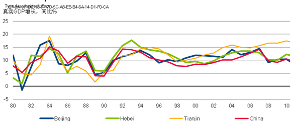
京津两个直辖市和河北省在20世纪80年代的发展达不到全国平均水平,这反映了中国的改革开放政策始于南方。然而,20世纪90年代起发生了变化,京津冀在这十年的平均增长水平都高过全国的数字。河北省在这期间发展最为强劲,天津在近十年赶超了河北省。有意思的是,2011年天津成为中国发展最快的直辖市,实际GDP同比增长16.4%,北京实际GDP增长排名最后,同比增长只有8.1%(见图1)。
图1 – 自2006年以来分化的增长表现
同比实际GDP增长 %
来源:中国数据库
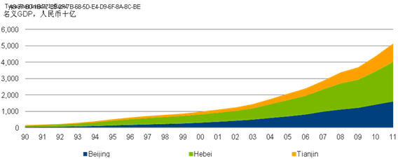
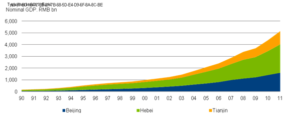
受强劲增长驱动,该地区经济规模已经在过去20年大幅增长,每5到6年就翻一番(见图2)。2011年,该地区GDP总量超过5万亿人民币,占中国总GDP的10%还多。20世纪90年代多数时期经济构成保持稳定,河北省占地区全部GDP的一半以上;北京的份额稳定在30%左右,天津占剩下的18%。2000年以来情况发生变化,北京的份额增加到35%,河北省的份额下降至47%。从2009年起,天津的份额开始上升,超过20%,北京又开始下降至30%。
图2 – 每5到6年地区经济翻番
名义GDP,人民币十亿
来源:中国数据库
该地区2010年总人口为1.05亿,比1990年的8000万略有上升,占全国人口的比率稳定在7-8%之间。人口增长最快的是北京,从1990年的1090万几乎翻番为2010年的1960万,复合年增长高达3%。河北省人口同期增长缓慢,从6200万增长到7200万,天津的人口增长也不快,从1990年的900万增长到2010年的1300万。
和经济与人口增长类似,人均收入的情况也很不同。北京和天津的人均GDP都接近全国平均水平的2.5倍,河北省的人均GDP仍然略低中国平均水平。
两个核心城中心强劲增长的积极溢出效应有限上文讨论的数字也表明,京津两地强劲增长对河北省的积极溢出效应有限,这个发现得到媒体有关北京周边“贫困带”报告的支持。亚洲开发银行在2004年就指出这一点,时至今日这显得更为触目惊心。当时,与中国其它都市区(比如广州或上海)相比,京津冀地区的经济差距已处于最高点。
人们经常把造成这种发展局面的原因归结为财政资源再分配不充分、把中央或国家利益置于当地发展之上、基础设施不足、缺少工业基础等。例如,河北省和北京市可比较的县之间,可用的财政资源的确差距巨大。自然资源也可以解释为何缺少趋同:北京的可饮用水库大部分都靠河北北部的河流补充。为了确保首都的饮用水供应,就鼓励这些地区的工农业减少用水。其它明显的例子是关闭河北省的工厂,以改善北京或天津的空气质量。同样重要的是,周边大部分县都被要求开展退耕还林,以防止进一步水土流失和沙漠化。虽然这都是重要议题,但是公共转移支付不足以补偿减少的工农业活动。
河北省和北京市某些地区联系不紧密,部分可以用地表特征来解释,比如北京西北部多山区。另外一个重要原因是北京本身面积很大,远郊区仍然是相对的农业地区,这限制了住房或工业发展向河北各县的延伸。此外,目前多数发展都集中在京津走廊这比较狭窄的区域,因为那里基础设施更好。
从积极角度来看,随着环首都经济圈的确立已经列入三地以及国家十二五规划,京津与周边河北县镇的正式合作有望提速。
第四部分:建议
该部分提出两方面的建议:1)有利于北京大力发展首都经济圈的具体发展领域;2)建议北京采取行动的领域,以期促进区域分工与合作。
1)北京发展综合性首都经济圈需要突破的领域
正如在第三部分所讨论的,与河北省的中型城镇以及农村地区相比,北京、天津和河北省省会石家庄相当发达。北京和天津更是处于城市化进程中的高级阶段,北京尤盛。北京的多样性和强劲的经济活动有利于企业和消费者。对北京而言,关键的挑战已经转移到宜居性。京津走廊地区或许处在中级和高级阶段之间,北京和天津港之间行业聚集已带来最近几年的快速增长。类似于东京-横滨和大阪-神户经济圈,京津之间更好的交通网络提高了效率和生产力。另一方面,河北省的中小城市、小城镇和农村地区仍处于早期阶段的城市化,经济活动主要集中在农业和资源。
鉴于北京、天津和河北省三地的多样性,建议采用综合的策略,以发挥不同领域的潜力和应对面临的挑战。
1. 连接政策:在城市中心之间创建新的集群
借鉴第二部分谈到的日本经验,北京应该考虑,在北京-天津和北京-石家庄之间的地区发展产业集群,而不仅仅是连接这些城市。创造新的集群也会提高河北省其它小城镇的工业规模,助其赶上全国的平均水平和缩小经济圈内的收入差距。
2. 宜居性:减少城市中心的拥堵、污染、资源负担
创造城市中心之间地区的新集群,也可以帮助改善宜居性,降低人口密度、缓解交通拥挤和紧张的水资源以及改善空气质量。另一个关键领域是发展公共交通系统,如前述案例研究中提及的纽约市地区。这样,不仅将解决北京的交通拥堵难题,而且将减少汽车废气排放,从而持续改善空气质量。北京已经在公共交通系统领域取得了很大进步,但是尚未实现类似覆盖纽约市、康涅狄格州和新泽西州的跨行政区域交通系统。
2)政府如何促进劳动力和合作的地区分工
正如在第一部分提及的,首都经济圈(或称为有效集聚)应该兼顾集群和城市化。一个有效的城市系统将实现不同行业的相互学习和借鉴。
1. 建立对话机制、联合规划与执行政策
经济圈内的各地政府需要有经常性的对话,加深对大城市及周边地区的动态和协同作用的理解。这方面的案例即在第二部分提及的柏林-勃兰登堡都市区,在官方国家规划和跨区域合作机制支持下的区域合作。还需要建立非正式的论坛,促进公众参与和社会各界的对话,这有助于增进沟通,建立互信。鉴于此,北京地区应该与其它地市的政府部门之间建立合作机制,并设立共同的规划部门,以保证更有效的实施。只要本着互利的原则,各地之间的竞争压力可能会带来更高的效率。
2. 向城市中心周边地区提供社会服务
这是北京有改进余地的领域,可以借鉴韩国的经验。尽管韩国有大约四分之一的人口生活在首都首尔市,一半以上生活在首都地区(包括首尔,仁川和京畿道),周围地区的社会福利并未被忽视。广泛地提供社会服务益处颇多。那些决定留在农村的人,不会感觉到被视为“二等公民”。此外,如果人们在农村地区享有良好的社会服务和生活水平,那么寻求到中心城市工作的经济移民数量将减少,从而减少了大城市的潜在的公共服务负担。因此,这些政策有助于实现社会和谐,从而减少国内政治风险。最后,提供充分的社会服务将增加居民的可支配收入和减少预防性储蓄,促进实现更为平衡、由内需驱动的经济增长。
Regional Cooperation and Development of the Economic Circle Around Beijing
——Josef Ackermann,Chairman of the Management Board and the Group Executive Committee,Deutsche Bank AG
Introduction
The focus of the paper is to investigate the current state of Beijing's integration with the cities, towns and counties of the surrounding province of Hebei and the neighbouring municipality of Tianjin. This area has different names and the boundaries are not always clear-cut. It is sometimes called Beijing-Tianjin-Hebei metropolitan area, referred to as Capital Economic Circle (CEC), or dubbed as extended Beijing-Tianjin Corridor. Regardless of which name one uses, it is a polycentric urban area with a diverse set-up: On the one hand, there is the megacity of Beijing as well as large cities like Tianjin (like Beijing under direct control of the central government) and Shijiazhuang (capital of Hebei province), both with populations in excess of 10 million people. On the other hand, there are medium-sized cities with populations of more than 2 million inhabitants, as well as towns and rural areas in Hebei province. The metropolitan area is undoubtedly dominated by Beijing, China’s political and cultural capital, and Tianjin, which is among the most important seaports of the country.
The paper is organised as follows: Part I gives an overview of the academic literature on the topic of economic geography and why it matters for socio economic development.
Part II takes a look at international case studies of metropolitan development. These include transformation experiences in developed economies as well as the development of metropolitan areas in emerging countries.
Part III of the paper describes the historical experience of Beijing and the surrounding areas of Hebei and Tianjin with respect to metropolitan development, focussing on economic convergence and giving an assessment of policy initiatives and potentially contentious issues.
In Part IV, building upon the theoretical framework developed in the earlier parts and taking into account historical experience and current stage of the metropolitan area, the paper closes with recommendations on how Beijing can achieve developing an integrated Capital Economic Circle.
Part I: Brief overview of economic geography
Although Asia has many large and sprawling cities or metropolitan areas, most were developed with little or no planning. As a result, many of these cities face problems such as pollution, congestion, poor quality of life, and health hazards for the population. Besides preventing the problems associated with poor planning, regions and cities would benefit from factoring in economic geography considerations into their development agenda to promote future growth prospect and sustainability. Economic geography, a cross-disciplinary study between economics and geography, looks at how geography shapes the location, distribution and organisation of economic activities – and vice versa. Economic geographers look at geographical factors that shape economic processes to explain, for example, the location of industrial or service clusters, – and it looks at how economic forces, such as external effects, cumulative advantages and economies of scale shape the locational distribution of economic activity and, by extension, into the causes of regional disparity, or the evolution of core-periphery areas. They seek to explain differences in development across different areas – why some areas prosper while others do not – and assess what can be done to help different areas realise their full economic potential. Explaining the causes of uneven development does not only help regions or cities create growth and prosperity; it also contributes to the prevention of potential crises.
In the earlier stage of economic geography, it concentrated on the agriculture sector, focused on the analysis of how climate and natural resources as well as labour supply shape development. Later on, factors impacting industrialisation came into focus, including the availability and quality of labour, wages, and technology and innovation. The objective back then was to determine the optimal location patterns for an efficient functioning of farms, factories or cities by taking into consideration geographical endowments and factors such as accessibility to ports and means of transport.
In the age of globalisation and emergence of multinational corporations (MNCs), intangible contributions to development have come under increasing focus. Social endowments such as institutions, networks, knowledge and culture play a key role in the decision about economic activities. Furthermore, economic activities are not always solely focused on production but also include new themes such as consumption, research and development, and organisational aspects of production. The net is also cast wider from urban or regional networks to the assessment of how a particular city or region fits into the national or international context. Globalisation has raised new and important questions about the interconnections and interdependencies among economies and about the processes through which regions develop and compete .
Nature (climate), geography, as well as companies, labour force and the state remain the key players in economic geography, but new factors such as external effects, innovation, and institutions are newly identified drivers that make a difference in development of different geographic areas.
Economic geography and Beijing
In what way can economic geography considerations benefit Beijing, already a vast metropolitan area? Beijing and the surrounding areas have an array of different activities ranging from agriculture, industrial production and various services including financial, transport, government and public services, education, healthcare, research, media and entertainment. With such vast activities within the same metropolitan area, questions arise whether synergies are being fully exploited.
In particular, it is worth exploring whether Beijing is profiting from the so-called “economies of agglomeration”, which depict the benefits that firms obtain when locating near each other. These in turn rest on economies of scale and network effects e.g. the sharing of labour pools and infrastructure. When firms in related industries cluster together, they can enjoy lower costs of production. Even if they are in the same sectors or are competitors, the clustering of firms will attract more suppliers, skilled labour and customers than a single firm would achieve on its own. As firms have a larger pool of suppliers to choose from, they enjoy higher bargaining power. Furthermore, clustering can lead to better division of labour and specialisation. Some cities are formed as a result of economies of agglomeration. In other cases, cities grow as a result of deliberate positioning to create agglomeration.
The two sides of agglomeration: clustering and urbanisation
To understand the benefits of economies of agglomeration, it is important to outline two concepts 1) clustering, which involves being near other producers of the same commodity or service; and 2) urbanisation, which means being close to producers of a wide range of commodities and services.
In clustering, proximity and immediate access to competitors in the same sector allows firms to stay abreast of market information, which in turn aids them in negotiating with customers and suppliers. Clustered firms can also share a larger and more dependable pool of specialised labour. Examples of clusters include the US IT industry in Silicon Valley and the US automobile industry in Detroit. The same applies to the financial industry in New York’s Wall Street and in the City of London, where banks, insurance companies and other financial firms benefit from being close to one another.
In urbanisation, the presence of a larger number of different industries in the same place can be beneficial to one another. For example, a management consulting company can benefit from locating near universities, business schools, financial institutions as well as manufacturers. The financial service industry in New York City and London thrives amongst the presence of the media industry, universities and transport hubs. Co-location also stimulates the growth of other specialist services, such as legal, accountancy, software, data processing, and advertising. The diversity also gains from the generation and diffusion of knowledge amongst one another and better understanding in the provision of service to their customers. As cities grow, urbanisation economies become more important. Urban diversity can foster the exchange of ideas and technology to produce greater innovation and growth.
Agglomeration can combine the benefits of both clustering and urbanisation. Economies of agglomeration depend not just on size i.e. how a big city or an industry is but also on urban interactions. They benefit from both within-industry economic interactions and from between-industry interactions. The sharing of capital inputs, information, and labour help lower the cost and improve efficiency. Productivity gains also arise from improving the match between production requirements and types of land, labour, and intermediate inputs as well as from learning about techniques and being inspired from products from other industries.
Urban systems: Understanding the dynamics of large cities and surrounding areas
Different urban systems in various parts of the world exhibit similar patterns. Larger cities tend to be more diversified and service-oriented. They innovate and are the breeding ground for new firms. Mature industries eventually fade away or relocate. Global cities such as New York, London, Paris, and Tokyo, are characterised by a diverse and predominantly service-based structure, supported by a labour force with a wide range of skills. Smaller cities tend to be more specialised in industry (industrial clusters). They engage in production or manufacturing activities and receive relocated industries from larger cities.
An urban system is made up of a few large diversified cities and many smaller, more specialised cities. New firms often start in diverse cities, but they move to smaller cities with specialised industry after they mature. In the US, almost all product innovations are in metropolitan areas. Industrial diversity and city size are both good for innovative output. Trial plants are based in large cities in Japan, but mass production plants are in small cities or rural areas. Young firms appear to need a period of experimentation to determine their ideal production process. In the early learning phase, diversified cities act as “nurseries” for firms to try out a variety of processes. Once a firm identifies its ideal process, it can begin mass production in specialised cities, where all firms share similar processes.
The World Bank notes that at different stages of urbanisation, policy priorities differ :
• Incipient stage. Areas of incipient urbanisation (urban share around 25%) are typically predominantly agricultural or resource-based, with low economic density. The priority is to facilitate agglomeration forces and to encourage internal economies of scale for plants, mills, and factories in towns, since it is not yet clear which places will be favoured by markets and for what purposes, policy makers should be neutral and take the cue from market forces.
• Intermediate stage. As urbanisation progresses (urban population around 50%), economic alliances strengthen within and between urbanised areas as firms and plants congregate to enjoy the synergy of sharing inputs and knowledge spillovers. Policy makers should put the promotion of localisation economies as top priority. Efficiency in production and transport systems is of great importance.
• Advanced. Diversity and intensity of economic activity delivers productivity and consumption benefits for highly urbanised areas. While functionality is the goal for industrial towns and cities in incipient and intermediate stages, livability becomes the most important goal for post-industrial metropolises (typically urban population around 75%).
Part II: Selected case studies from metropolitan Economic Circle development around the world
This section presents four case studies which depict different aspects which are relevant for the metropolitan Economic Circle development. First, the Tokyo-Yokohama and Osaka-Kobe case illustrates successful economic circle development in the Japanese capital and nearby port city which offers potentially useful parallels to the Beijing-Tianjin experience. Second, the example of New York City’s connectivity with surrounding areas is relevant in terms of transportation systems from which Beijing can learn from as it faces the monumental task of managing its ever-growing car population. The third example draws upon South Korea and how the government actively supported welfare and social services for the population in the province surrounding Seoul, an experience upon which Beijing can learn from in order to foster closer co-operation with Hebei province. Finally in the fourth example, the case of Berlin and Brandenburg in Germany is used to discuss some administrative aspects related to the relationship between a core city and its neighbouring rural province which, again, may be useful in the context of Beijing and Hebei province.
1. Tokyo-Yokohama and Osaka-Kobe: Industry and geography
Japan’s manufacturing industries are spatially concentrated. In Tokyo both state-owned factories and private industrial complexes were concentrated along the main river. Gradually small machinery workshops conglomerated, and industries expanded toward the south along the new Tokaido railway connecting Tokyo, Yokohama, and areas further south. After World War II, when exports to the United States began to accelerate, industrial production became concentrated in the Keihin industrial zone around Tokyo and Yokohama, and in the Hanshin industrial zone around Osaka and Kobe.
This led to heavy traffic congestion, water shortages, and air and water pollution. In 1962 the Japanese government responded by instituting Zenso, the Integrated Spatial Development Plan, which aggressively developed the Pacific Ocean Industrial Belt by linking the core agglomerated areas between Tokyo and Osaka and establishing new industrial zones in between. The investments included the bullet train (Shinkansen) and other trunk railways, expressways, and ports.
During the growth era of the 1950s through 1970s, industries remained spatially concentrated, thanks to the mobility of workers, even though there had been massive relocation of industries from the congested core to surrounding new industrial areas. Enterprises that remained in core urban clusters upgraded from standardised to high-tech products by taking advantage of urbanisation economies accruing from diverse economic activities and a large pool of skill and talent.
Industries that left the traditional industrial cores were mostly exporters of machinery and electronic appliance plants. They continued to enjoy localisation economies from producing similar and related products in new clusters. Their locations alongside the Tomei highway connecting Tokyo and Nagoya gave easy access to markets and high-tech enterprises in the urban centres. The geographic distribution of industries over several decades of rapid growth reflected the government’s efforts to promote concentration while preventing the grime and time costs of rising density. These efforts did not interfere with the profit motives of enterprises, but instead strengthened agglomeration economies. Government policies and market forces reinforced each other spatially to sustain economic growth.
2. New York City: Mass transportation is crucial to ensure smooth functioning of core city and surrounding areas
New York City provides an example of the changing institutions necessary for spatially connective policies. Their interaction enabled the density of Manhattan, the Bronx, Brooklyn, and Queens to increase from 230 people per square kilometre in 1820 to more than 5,000 in 1900 and about 12,000 today. Successful urbanisation requires connecting ever wider areas. Inevitably, density brings crowding. New York shows the enormous benefits of an efficient metro system in reducing congestion while encouraging density.
The key is an integrated system of mass transport. Dense city centres and skyscrapers are feasible only when thousands of office workers can be transported efficiently to downtown offices. It has been a never-ending struggle to expand the transport system fast enough to accommodate population growth. Most of the subway system in use today was built between 1913 and 1931; the number of annual rail passengers jumped from 500 million in 1901 to 2.5 billion in 1929. In 1940 the city unified the three independent subway lines under public ownership, allowing for a more integrated approach to transport development.
The payoff is inclusive and sustainable urbanization. New York’s Metropolitan
Transportation Authority has served a 5,000-square-mile region since 1968. According to the 2000 U.S. census, New York City is the only locality in the United States where fewer than half of all households own a car — the figure is even lower in Manhattan at fewer than a quarter — compared with 92 percent nationally. One in every three users of mass transit in the United States and two-thirds of the nation’s rail riders live in New York City and its suburbs.
3. Korea: Providing social services to surrounding province near Seoul metropolis for more efficient rural-urban transformation
In 1960 the Republic of Korea had a GDP per capita level roughly the same as Benin, Cambodia, or Tajikistan. Since then it has transformed itself into a leading industrial country. Korea’s sectoral transformation has been accompanied by an equally radical spatial transformation. In 1960 about 75% of all Korean citizens lived in rural areas. Today, the urban share of the population exceeds 80%.
Institutions to ensure the universal availability of basic social services helped the nation lay the foundations of rapid and successful urbanisation. In 1960 the proportion of the overall population age 15 and over with no schooling was 36%. By 2000, some years after it entered the advanced stage, the proportion was less than 5%. The years of schooling of the average member of the labour force had increased from 5 years in 1960 to 9 years in 1980, rising to more than 12 years by 2000. A similar story unfolded for health-related services. In 1980 only 4 % of children were immunised against measles. In 2006 only one child in every 100 was not immunised.
A good match for the universal provision of education and health services has been the nationwide flexibility in land use conversion. In particular, Korea’s central government has been willing to convert agricultural land for industrial purposes and encourage local governments to do the same. Eumseong County, a largely rural area in Chungcheongbukdo province southeast of Seoul, is a prime example. As Korea industrialised and urbanised, Eumseong experienced a continual outflow of people. In 1968 the population exceeded 120,000, but by 1990 it had fallen to just under 75,000. But even as the people of Eumseong were seeing their neighbours move closer to Korea’s major cities, they got better education and health services and improved streets and sanitation. Between 1969 and 1990, middle and high school teachers tripled in Eumseong County from 1,000 to around 3,000. And the number of hospitals per million population in Chungcheongbukdo province doubled from around 400 in 1980 to 800 in 1990, while the water supply coverage increased from less than 30% to almost 60%. People left Eumseong, but the Korean government did not abandon the county — instead, it continued to emphasise the universal provision of basic and social services.
4. Berlin Metropolitan area: Organising the administration of an urban state with a hinterland state
Regional cooperation in the metropolitan region of Berlin-Brandenburg is carried out mainly through a regional joint planning department. In Germany, the government is composed by three levels which are the federation, the state and the local. The federal government participates in the local area development through national laws and financial support. The local government has autonomous right to make decisions for local affairs. Berlin, an urban state in Germany, has a population of about 3.4 million and an area of 889 square kilometres. Brandenburg State has a much wider area of 29,000 square kilometres closely surrounding Berlin, but population only about 2.55 million.
The metropolitan region is formed with Berlin as the core of the metropolis with a total area of 30,000 square kilometres and population of about 6 million, around 3.5 million in Berlin and 1.5 million in Potsdam, the capital of Brandenburg and the rest scattered in smaller towns in the state of Brandenburg. High density of urban space in Berlin, and large area of agriculture and scattered settlements in Brandenburg demonstrate the great disparities in economy, structure and geography between the central city and its hinterland. Berlin, like Beijing, is a multi-cultural metropolitan city. It is the centre of federal government, federal parliament, the seats for federal government departments, with a vibrant presence of institutions in businesses, finance, science, medicine, education as well as social and cultural institutes. It is also home to embassies and foreign countries’ representative offices.
Since the reunification of Germany in 1990, social and economic communications and population flow between the new capital Berlin and Brandenburg State rose in frequency. The administrative borderline of these two states still segregated the nuclear city from its suburbs. Different administrative territories made it impossible to manage the population transitions and the requirement of service facilities crossing the state boundaries. Therefore, the state governments started to promote the merging of these two states since 1991. However, the referendum held in 1996 on the ‘Merging Act’ failed. The objection came mainly from Brandenburg State. Since Berlin had always been the ruler in the region, people from Brandenburg were afraid of having to sacrifice their interests to the benefits of Berlin (in particular, taking over Berlin’s debt) after the merger.
Although the merger of the two areas failed, regional collaboration still proceeded. The official inter-state planning and cooperative mechanism, “Berlin-Brandenburg Joint Spatial Planning Department” was established in Potsdam in 1996. This planning department is unique in Germany. It has direct political rights to make and execute planning decisions at the federal state level.
Besides the formal regional planning and regional cooperative institution, informal forums which promote the public participation and the dialogue among all social sectors help to enhance communication, strengthen mutual understandings and construct cooperative trust. However, achieving a harmonious regional cooperation among different levels and layers of administration units is challenging. Moreover, the emphasis on equality means that decisions have to be made on the basis of mutual agreement by both states, which can slow down the decision-making process and speed in responses. Another drawback of the joint planning system is that there is no co-operation mechanism in other departments of the state government. Inter-regional cooperation tends to be followed in areas such as public relations and planning, but not always in other areas.
The multi-centre urban structure of Berlin does not guarantee a completed balanced development. There are differences between the East and West Berlin and between central urban districts and marginal urban districts. Competition are emerging among the urban districts with regard to the image of each district and improving the quality of the urban area. At the same time, the pressure caused by economic competition from surrounding local autonomous communities of Brandenburg is still present.
Part III: The experience of Beijing and surrounding areas with respect to metropolitan development
The Beijing-Tianjin-Hebei metropolitan region or, catchier, Capital Economic Circle (CEC), is a polycentric urban area , with a diverse set-up. On the one hand, there is the megacity of Beijing as well as large cities like Tianjin (as Beijing under direct control of the central government) and Shijiazhuang (capital of Hebei province), both with urban populations in excess of 10 million people. On the other hand, there are medium-sized cities, as well as towns and rural areas, in Hebei province. With a total population of 105 m the region is home to more than 8% of China’s total population, while at the same time, producing more than 10% of China’s national GDP. Beijing is China’s political and cultural capital and Tianjin is among the most important seaports worldwide, ranking number 11 globally in terms of container throughput and number 6 when looking at cargo tonnage.
Looking back: Economic performance at the provincial level
In terms of real GDP growth, the two municipalities of Beijing and Tianjin as well as Hebei province have shown weaker-than-nationwide growth on average in the 1980s, a reflection of the fact that China’s reform and opening-up policy experiment started out in Southern China. This picture changed, however, from the 1990s, when the decade-average was higher than the nationwide figure for all three provinces. Hebei province posted the strongest growth during this period, while Tianjin took over in the last decade. Interestingly, in 2011 Tianjin was China’s fastest growing province, increasing its real GDP by 16.4% yoy, whereas Beijing ranked last in terms of real GDP growth, posting an expansion 8.1% yoy (see Figure 1).
Figure 1 – Diverging growth performance since 2006
Real GDP growth, % yoy
Source: CEIC

Driven by strong growth, the area’s economic size has increased significantly over the last 20 years, doubling every five to six years (see Figure 2). Total regional GDP crossed RMB 5 trillion in 2011, accounting for more than 10% of China’s total GDP. Composition has remained stable for most of the 1990s, with Hebei accounting for more than 50% of total regional GDP; Beijing’s share stable around 30%, and Tianjin making up the remaining 18%. Things changed in the 2000s, when Beijing’s share increased to up to 35% while Hebei’s share dropped to 47%. From 2009 on, Tianjin’s share started to rise, crossing 20% while Beijing started to decline again back towards 30%.
Figure 2 – Regional economy doubling every five to six years
Nominal GDP, RMB bn
Source: CEIC
The region has a total population of 105 m in 2010, up from slightly more than 80 m in 1990. The share in the national total has remained broadly stable around 7-8%. Strongest population growth has been in Beijing, which almost doubled its population from 10.9 m people in 1990 to 19.6 m in 2010, translating into 3% compound annual growth. During the same time, population growth was much slower in the case of Hebei, rising from around 62 m to 72 m, and population was increasing at slower pace in Tianjin as well, to 13 m in 2010, up from 9 m in 1990.
As for growth and population, the picture is diverse in terms of income per head. Beijing and Tianjin both are boasting GDP per capita close to 2.5 times the national average, whereas Hebei’s GDP per capita is still slightly below the average for China.
Limited positive spillovers from strong growth in the two core urban centres
The numbers discussed above suggest that positive spill-overs for Hebei province from robust growth in Beijing and Tianjin municipalities have been limited, a finding supported by press reports talking about Beijing’s “poverty belt”. This is even more alarming as the Asian Development Bank (ADB) pointed this out already back in 2004. Back then, the discrepancy in economic well-being was the highest in the Beijing-Tianjin-Hebei area when compared to other metropolitan areas in China, like for instance Guangzhou or Shanghai .
Often-cited reasons for this development include shortcomings in the redistribution of fiscal resources, prioritising of central or national interests over local development, infrastructure shortcomings, lack of industrial basis etc. For instance, comparable counties in Hebei province and in Beijing municipality do show huge differences in terms of available fiscal resources. Natural resources also play an important role in explaining lacking convergence: A large share of Beijing’s potable water reservoirs are fed by rivers from Northern Hebei province. In order to ensure drinking water supply to the capital, industry and agriculture in those areas are encouraged to cut down on water usage. Other prominent examples are the shutting down of factories in Hebei province in order to improve air quality in Beijing or Tianjin. As importantly, large parts of neighbouring counties have been ordered to follow reforestation programmes in order to prevent further soil degradation and desertification. While certainly an important issue, public transfer payments were not enough to offset losses from reduced agricultural and industrial activity.
Weak connectivity between certain areas in Hebei province and Beijing can be partly explained by topographic features, like mountainous areas in the Northwest of Beijing. Another important reason, however, is the large area of Beijing itself and the prevalence of still relatively rural areas in the outer suburbs, which limits the need of reaching out to Hebei province counties for housing or industrial developments. In addition, most development so far took place in the narrower Beijing-Tianjin corridor, which sports better infrastructure.
On a positive note, formal cooperation between Beijing (and Tianjin) on the one side and neighbouring counties and towns in Hebei province on the other side could potentially speed up as the establishment of the Capital Economic Circle has been included in all three provinces’ as well as the National 12th Five-Year Plan.
Part IV: Recommendations
This section is structured around two main strands of recommendations: a) specific areas where Beijing can make a substantial impact in developing an Economic Circle around the capital; and b) suggested areas for action with a view to promote the regional division of labour and cooperation.
a) Where shall Beijing make a breakthrough in developing an integrated Capital Economic Circle?
As discussed in Part III, Beijing, Tianjin and to a certain extent Shijiazhuang, capital of Hebei province, are relatively more developed compared to the medium-sized cities and towns as well as rural areas in Hebei province. Beijing and Tianjin in particular are at a more advanced stage of urbanisation. Beijing core is in an advanced stage where diversity and intensity of economic activities deliver benefits to both companies and consumers. The key challenge for Beijing has thus shifted to the issue of livability. The Beijing-Tianjin corridor is perhaps between the intermediate and advanced stages, where economic benefits from conglomerations of industries and businesses between the Beijing and Tianjin ports have led to fast growth in recent years. Better transport networks between the two cities have improved efficiency and productivity, similar to the experience of Tokyo-Yokohama and Osaka-Kobe. On the other hand, the medium-sized cities, small towns and rural areas of Hebei province are still in incipient stage of urbanisation, where economic activities are largely agriculture or resource-based.
Given the existing diversity in the three areas of the Economic Circle, an integrated approach that addresses the potential and challenges faced by the different areas will be required.
1. Connective policy to create new clusters between urban centres
Taking a leaf from Japan’s experience as presented on Part II, Beijing should look into promoting industrial clusters in areas between urban centres such as Beijing-Tianjin or Beijing-Shijiazhuang rather than merely connecting the urban centres. Creating new clusters would also improve economies of scale for plants, mills, and factories in smaller towns in Hebei province, helping them to converge to the national average and reducing the income gap within the Economic Circle.
2. Livability: Reducing congestion, pollution, and burden on resources of the urban centres
Creating new clusters between urban centres can also help to improve livability in the urban centres by spreading out population density, relieving the traffic congestions and strain on water resources as well as improving the air quality. A second key area, as pointed out in the case study of the New York Metropolitan area, is to develop a public transport system. With that, not only will Beijing solve its notorious gridlock traffic problem, but the air quality would improve substantially and sustainably with the reduction of exhaust fume from automobiles. Beijing has already made good progress in mass transportation, but it is not yet as extensive as the New York mass transport system, which reaches three states, namely New York, Connecticut and New Jersey.
b) How shall the government promote regional division of labour and cooperation?
As mentioned in Part I, the aim of the Economic Circle or effective agglomeration should be to combine the benefits of both clustering and urbanisation. An effective urban system will lead to different industries learning from one another or drawing inspiration from products from other industries.
1. Adoption of mechanisms for dialogue and joint planning & implementation of policy
The governments of the different areas within the Economic Circle need to have a frequent dialogue to deepen their understanding of the dynamics and synergies of large cities and surrounding areas. In this regard, the example of Berlin-Brandenburg as presented in Part II, where regional collaboration is supported by an official inter-state planning and cooperative mechanism is a case in point. The existence of informal forums to promote the public participation and the dialogue among all social sectors helps to enhance communication and create mutual trust. To build upon this idea, Beijing could look into instituting co-operation mechanisms in other departments of the state government in addition to having a joint planning department in order to assure a more effective implementation. Competitive pressures between the various local autonomous communities involved may actually be productive - as long as the spirit of mutual benefit prevails.
2. Providing social services to surrounding areas of the urban centres
This is an area where Beijing has room for improvement and can look to the experience of Korea for inspiration. Despite the fact that around a quarter of the country’s population lives in Seoul capital city and more than half live in the National Capital City area (comprising of Seoul, Incheon and Gyeonggi-do), the welfare of the surrounding rural areas has not been neglected. Universal provision of social services provides many benefits. Those people who decide to stay in rural areas do not feel like “second class” citizens. Also, if they enjoy good social services and living standards, fewer economic migrants will seek jobs in urban centres, thus reducing the potential burden on public services in the big cities. Thus, these policies are likely to reduce increase social peace, thus reducing domestic political risk. Finally, providing the population with adequate provision of social services will increase their disposable income and reduce precautionary savings, boding well for more balanced, domestic demand-driven economic growth.

主办:中国国际贸易促进委员会北京市分会
建设运维:北京市贸促会信息中心
京ICP证12017809号-3 | 京公网安备100102000689-3号